
|
Designing geodatabases for transportation
|
J. Allison Butler |
xv, 461 pages : 23 cm |
OL15105000W |

|
Alexander Nimmo's Inverness survey & journal, 1806
|
Alexander Nimmo |
Alexander Nimmo was Rector of Inverness Academy in 1806 when the Commission for Highland Roads and Bridges employed him to survey the boundary of Inverness-shire with the adjacent counties. During hi… |
OL15990921W |
|
La cartografia per l'urbanistica e l'architettura
|
Luca Marescotti |
Atti del “1 Seminario di Cartografia”, organizzato al Politecnico di Milano nei giorni 29, 30, 31 marzo 1982 da Luca Marescotti, professore e responsabile della sezione Cartografia del Centro di Docu… |
OL16272080W |
|
Maphead
|
Ken Jennings |
This book traces the history of mapmaking while offering insight into the role of cartography in human civilization and sharing anecdotes about the cultural arenas frequented by map enthusiasts. It c… |
OL16441491W |
|
Japoniæ insulæ. The mapping of Japan. A historical introduction and cartobibliography of European P…
|
Jason C. Hubbard |
The Mapping of Japan systematically categorizes and provides an overview of all the European printed maps of Japan published to 1800. The author has undertaken a review of the literature, conducted a… |
OL16798875W |
|
The Cartographer Tries to Map a Way to Zion
|
Kei Miller |
72 pages ; 22 cm |
OL17564448W |

|
Cartografía social
|
Juan Manuel Diez Tetamanti,Beatriz Escudero |
Las cartografías sociales se presentan como una nueva oportunidad de aplicación de formas de conocimiento y posibilidades de intervención social a nivel local. Reconocen desde su práctica una nueva f… |
OL17767867W |

|
Map scales
|
Jennifer M. Besel |
"Simple text with full-color photos and illustrations provide basic information about map scales"--Provided by publisher. |
OL17872653W |

|
Introducción a los SIG
|
Víctor Olaya |
Libro sobre los fundamentos de los Sistemas de Información Geográfica. Esta obra es un breve resumen de la obra *Sistemas de información geográfica* (2014). |
OL17883896W |

|
Global positioning systems
|
Laurie Collier Hillstrom |
Explores global positioning systems, tracing the history and scientific breakthroughs leading to their creation. |
OL17893210W |
|
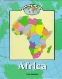
Africa
|
Fran Sammis |
Text and maps introduce information about the climate, regions, people, cultures, animals, plants, resources, politics, and religions of Africa. |
OL1844821W |
|
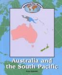
Australia and the South Pacific
|
Fran Sammis |
Text, photographs, and maps introduce information about the climate, land use, resources, plants and animals, population, politics, and religions of Australia, New Zealand, and the islands of the Sou… |
OL1844823W |
|
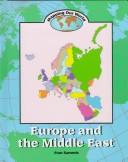
Europe and the Middle East
|
Fran Sammis |
Presents information about the physical features, climate, land use, political divisions, religions, languages, population, transportation, plants, animals, and other aspects of Europe and the Middle… |
OL1844829W |

|
Standardizing land cover mapping for tsetse and trypanosomiasis decision making
|
Food and Agriculture Organization of the United Nations |
The habitat of tsetse fly depends upon climatic conditions, host availability and land cover characteristics. In this paper, the Land Cover Classification System, developed by FAO and UNEP, is propos… |
OL18662972W |

|
On the map
|
Simon Garfield |
Examines the pivotal relationship between mapping and civilization, demonstrating the unique ways that maps relate and realign history, and shares engaging cartography stories and map lore. |
OL19667916W |

|
The red atlas
|
John Davies,Alexander James Kent |
xiii, 234 pages : 24 cm |
OL19722717W |

|
Transportation Systems Engineering: Theory and Methods
|
Ennio Cascetta |
This book provides a systematic and rigorous presentation of the theory of transportation systems and of the main methodologies for its application to transportation system engineering. Topics are pr… |
OL19907801W |

|
A history of the world in twelve maps
|
Jerry Brotton |
"A fascinating look at twelve maps-from Ancient Greece to Google Earth-and how they changed our world In this masterful study, historian and cartography expert Jerry Brotton explores a dozen of histo… |
OL19972485W |
|
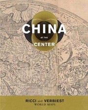
China at the center
|
Natasha Reichle,Theodore N. Foss,Mark Stephen Mir |
"Global exploration in the sixteenth and seventeenth centuries led to new interactions between Europe and Asia. Jesuit priests were instrumental in spreading knowledge of the world to China and infor… |
OL20022261W |
|
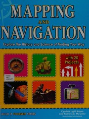
Mapping and navigation
|
Cynthia L. Brown |
Whether mapping the solar system or mapping their own backyard, young readers will be able to understand mapping technologies and see the world in new and exciting ways with this interactive, educati… |
OL21412509W |