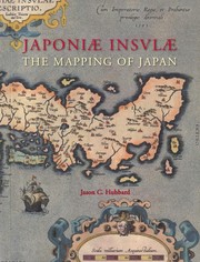
Japoniæ insulæ. The mapping of Japan. A historical introduction and cartobibliography of European Printed Maps of Japan before 1800.
By Jason C. Hubbard
Subjects: Cartography, Maps, Japan, maps, Early works to 1800, History, Early maps, Bibliography
Description: The Mapping of Japan systematically categorizes and provides an overview of all the European printed maps of Japan published to 1800. The author has undertaken a review of the literature, conducted an exhaustive investigation in major libraries and private collections, analyzed these findings and then compiled information on 125 maps of Japan. The introduction contains information about the mapping to 1800, the typology of Japan by western cartographers, an overview on geographical names on early modern western maps of Japan and a presentation of the major cartographic models developed for this book. This is the fourteenth volume in the Utrecht Studies on the History of Cartography. This series is prepared under the direction of the Research Program URU-Explokart of the University Utrecht. In English with Japanese summary. With 374 full colour illustrations.
Comments
You must log in to leave comments.